Megan Poling research

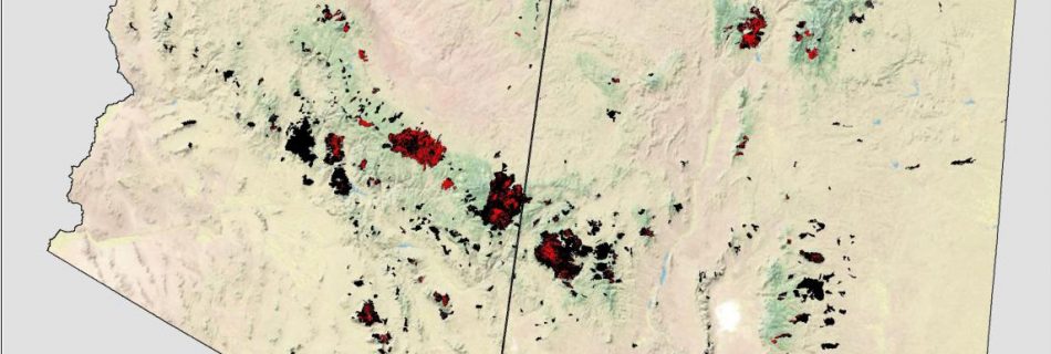
August 24, 2016: Increasing trends in high severity fire in the southwestern USA from 1984-2013

Presenter: Megan Poling, PhD Student, Northern Arizona University In the last three decades nearly 5 million hectares have burned in all vegetation types in the Southwest and the largest fires in documented history have occurred in the past two decades. However, trends in severity, or how fires are burning have not been well documented in forest …

January 20, 2016: Biophysical Settings Review: What it is. How it works. Why it matters

Date: Wednesday January 20, 2016 12pm Mountain Presenter: Randy Swaty, The Nature Conservancy LANDFIRE Team All ecosystems are dynamic, changing due to growth, succession and disturbances. Modeling large landscapes in the United States requires the collective knowledge of experienced and knowledgeable vegetation and fire experts. In collaboration with hundreds of colleagues, LANDFIRE produced more than 1,000 state-and-transitions …

June 20, 2012: Fire Regime Condition Class Concepts

Presenter: Steve Barrett & Kathy Schon (NIFTT University of Idaho) Fire Regime Condition Class (FRCC) is an interagency, standardized tool for determining the degree of departure from reference condition vegetation structure and composition and fire regimes. FRCC metrics can help guide management objectives and set priorities for treatments. This webinar introduces the participant to the theories …

January 21, 2015: The Ability of Wildfire to Act as a Fuel Treatment

Presenter: Sean Parks, Aldo Leopold Wilderness Research Institute, Rocky Mountain Research Station, U.S. Forest Service In partnership with the Northern Rockies Fire Science Network, Sean will present the results from a JSFP-funded study that highlights the ability of wildfire to act as a fuel treatment. This study evaluated whether or not wildfires limited the occurrence, …

March 12, 2014: Identifying Priority Treatment Areas Across the Apache-Sitgreaves National Forests

Presenter: Joe Crouse, Ecological Restoration Institute To address concerns regarding how to prioritize treatments across the forests, the Ecological Restoration Institute received funding from the USDA Forest Service to identify priority treatment areas across the Apache-Sitgreaves National Forests. In addition, Forest Service personnel stated a need to identify areas within the Wallow Fire perimeter that …

May 15, 2013: The Structure of Fire Size Distributions: A Broad View of Interacting Gradients in Wilderness Management, Spatial Climate, and Topography in Three Western Regions

Presenter: Sandra Haire, Haire Laboratory for Landscape Ecology Determining the effects of land management on fire regime characteristics is complicated by the interaction of several factors that vary in space and time. First, fire size and frequency are linked to climate conditions, including drought, as well as wind and temperature that define weather conditions during …

March 2012: FRCC Workshop – (Albuquerque, NM and Flagstaff, AZ)

Fire Regime Condition Class (FRCC) assessments have been widely used for evaluating ecosystem status in many areas of the U.S. FRCC employs state-and-transition modeling to describe historical vegetation and fire regimes, which provides reference information related to landscape fire frequency, severity, and vegetation composition. Similarity indexing is used to compare historical versus current vegetation and …

May 16, 2012: Wildland Fire Assessment Tool

Presenter: Eva Strand & Josh Hyde (NIFTT University of Idaho) WFAT provides an interface between ArcMap, FlamMap 5, and the First Order Fire Effects Model (FOFEM), combining their strengths into a spatial fire behavior and fire effects analysis tool in GIS. In the webinar, you will learn how to use WFAT to locate potential fuel …

March 18, 2012: Fire Regime Condition Class Mapping Tool

Presenters: Steve Barrett & Jeff Jones (NIFTT University of Idaho) The FRCC Mapping Tool quantifies the departure of vegetation conditions and fire regimes from a set of reference conditions representing the historical range of variation. The tool, which operates from an ArcGIS platform, derives several metrics of departure (e.g., vegetation composition and structure, fire severity, …